I Got My DGCA RPAS Pilot Certificate. Here's What the Exam Doesn't Teach You.
I cleared the DGCA Remote Pilot Certificate exam last week through Sanskardham Drone Academy, Ahmedabad — a DGCA-approved Remote Pilot Training Organisation. The programme ran across five days total for the Small category certificate (drones above 2 kg up to 25 kg): two days of online ground theory and a written exam covering drone systems, air regulations, and meteorology, followed by three days of hands-on flight training and the practical test. The certificate is now issued through the Digital Sky Platform and is valid for ten years.
Here is the honest take: the exam tests a real and specific body of knowledge. It is also almost completely orthogonal to what it takes to actually engineer a safe drone.
That is not a criticism of the DGCA. The exam is designed to produce competent operators of certified commercial UAS — and for that purpose, the syllabus makes sense. But I build custom flight controllers from ground up. I write attitude estimators, design power trees, and implement failsafe state machines. The knowledge those systems require and the knowledge the RPAS exam requires overlap only partially, and understanding where they diverge is useful for any engineer who operates in both spaces.
What the Exam Actually Covers
The RPAS RPC syllabus for Small category drones (above 2 kg) covers five broad areas:
Air Regulations — the Drone Rules 2021, airspace classification, DGCA enforcement mechanisms, the Bharatiya Vayuyan Adhinayam 2024, accident reporting obligations (within 48 hours to DGCA via Digital Sky), penalties (up to ₹1,00,000 per violation), and ICAO-derived operating standards.
Aviation Meteorology — pressure systems, wind patterns, cloud classification, visibility conditions affecting UAS operations, monsoon effects on low-altitude flight, and how to read basic weather advisories.
Air Navigation — latitude/longitude, basic chart reading, GPS as a navigation aid, the Green/Yellow/Red airspace zone system on the Digital Sky Interactive Airspace Map, and how to compute simple distance and time problems.
Drone Systems — general UAS architecture, the roles of the Ground Control Station, the Remote Pilot, and the UAS itself under DGCA definitions, pre-flight checks as a procedural sequence, and the purpose of the NPNT (No Permission No Takeoff) system.
Emergency Procedures — operational responses to loss of control link, GPS failure, low battery, and fly-away scenarios.
The exam is multiple-choice, with a 70% pass threshold. The questions are procedural and regulatory — not mathematical, not analytical.
The practical component at Sanskardham covered roughly 4.5 hours of actual stick time and 2.5 hours of simulator training. The test aircraft was a 680 mm quadcopter with 13-inch carbon fibre props — a type-certified platform. The maneuver syllabus was more demanding than I expected: squares and circles at fixed altitude, figure-8 patterns, angle turns with coordinated heading changes, controlled ascent and descent profiles, and three mission-specific exercises — stadium sweeps (a lawnmower-pattern area survey), tower circling (fixed-radius orbit at varying altitudes), and an automated waypoint survey using the ground station’s mission planner. The emergency procedure training covered three specific scenarios: geo-fence breach triggering automatic Return-to-Launch, radio disconnect triggering RTL with a configurable timeout, and disorientation recovery — re-establishing aircraft orientation from a confused or inverted mental model without looking at the screen.
The Three Zones: What the Airspace Map Actually Looks Like
India’s Digital Sky Interactive Airspace Map divides the country into three colour-coded zones structured around a concentric geometry from every controlled airspace boundary. The diagram below shows the cross-section for an airport — the most common reference point for zone classification.
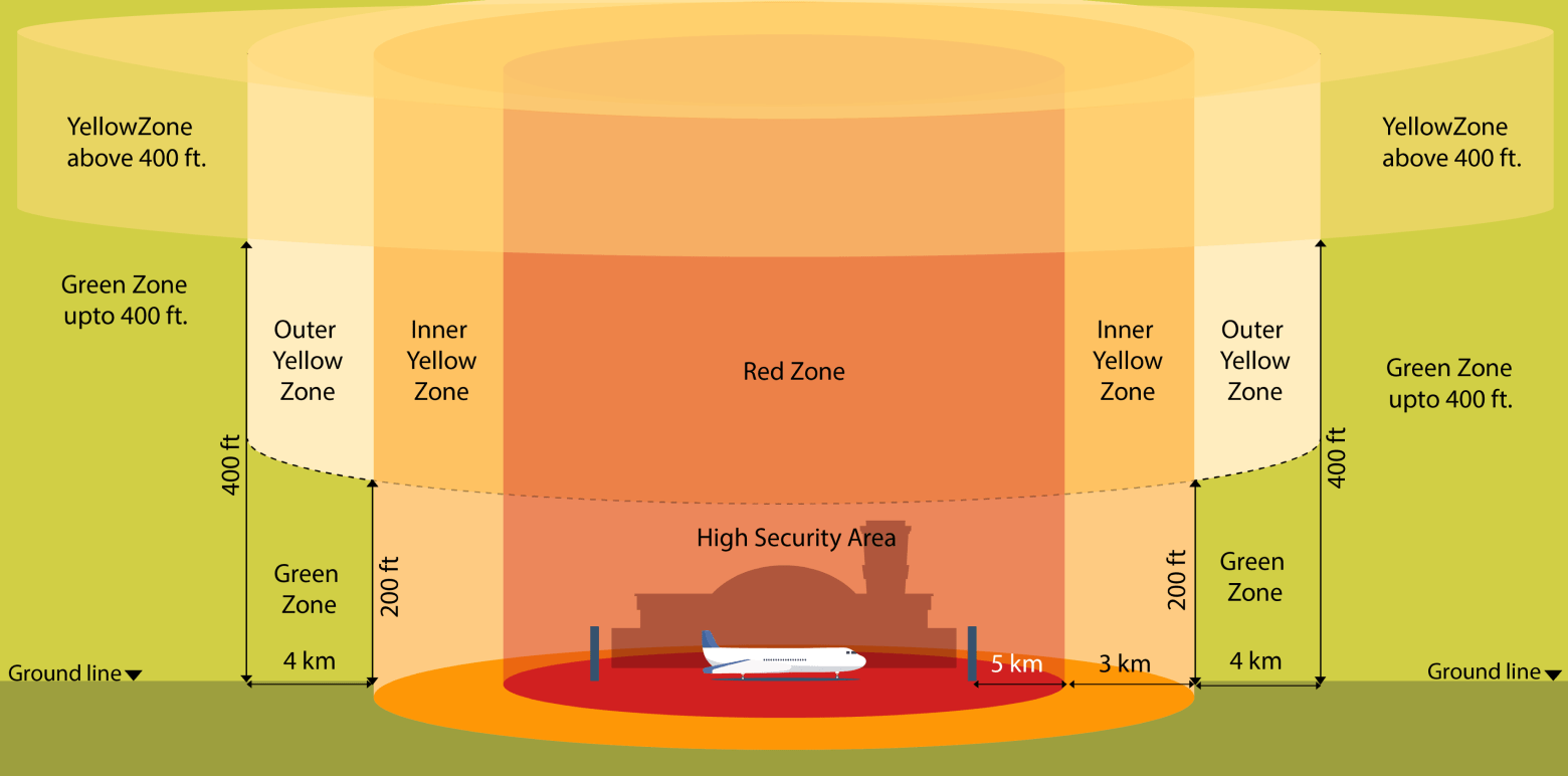
Cross-section of DGCA airspace zones around a controlled airport. The Red Zone and High Security Area are no-fly for civilian UAS. The Inner and Outer Yellow Zones require prior Digital Sky permission. Green Zone operations up to 400 ft are permitted for registered drones without prior approval.
Red Zone — No fly, full stop The Red Zone begins at the airport boundary and extends to 5 km radius from the nearest runway. Within this, the High Security Area (the airport itself) is an absolute exclusion zone. Civilian UAS operations in Red Zones are not permitted under any standard RPC authorisation. Flying here — even unknowingly — attracts penalties up to ₹1,00,000 and potential certificate suspension under the Drone Rules 2021.
Permanent Red Zones also cover military installations, the Rashtrapati Bhavan complex, Parliament, nuclear facilities, and ISRO/DRDO research sites. Temporary Red Zones are declared for VIP movements, elections, and major sporting events — these appear on Digital Sky with an activation time window and must be checked before every flight.
Yellow Zone — Permission required, typically approved within 24 hours Yellow runs from the Red Zone boundary outward in two bands: an Inner Yellow Zone (3–5 km from airport reference) and an Outer Yellow Zone (5 km to approximately 12 km depending on airport category). Above 400 ft AGL, Yellow Zone rules apply even in areas that are Green at ground level.
You file a flight permission request on Digital Sky with your planned polygon, altitude ceiling, and time window. Low-risk missions with standard parameters are usually approved algorithmically within minutes to a few hours. Unusual requests — extended BVLOS, night operations, anything near the Inner Yellow boundary — go to manual DGCA review, which is slower and less predictable.
The critical thing the diagram makes clear: the zone boundary is not visible on the ground. A field 6 km from an airport that looks entirely rural is Yellow Zone. Always check the Digital Sky map before assuming any location is uncontrolled.
Green Zone — Fly with registration, no prior permission needed Beyond the Yellow boundary and below 400 ft AGL, registered drones can fly without a prior permission request. You still need to log the flight on Digital Sky, but there is no approval wait time. Most rural and semi-urban India falls here. For development and testing work away from cities, this is where practical flight sessions happen.
What the Exam Gets Right
This is not a dismissive take. The exam tests knowledge that genuinely matters for safe operations.
Airspace literacy is not trivial. India’s Digital Sky zone map is more nuanced than it looks. The boundary between a Green zone and a Yellow zone is not always obvious from satellite imagery. Yellow zone approval timelines, the correct procedure for filing a mission declaration, and the difference between a temporary Red zone (VIP movements, elections, sporting events) and a permanent Red zone (3 km from airports, nuclear facilities, Parliament) — all of this has real operational consequences. Getting it wrong exposes you to penalties and could ground a legitimate mission at the wrong moment.
Meteorology at operational altitude matters differently than it does at cruise altitude. Low-altitude UAS operations are more sensitive to surface wind gusts, thermal turbulence in Indian summer conditions, and sudden visibility loss from dust/haze than a manned aircraft at 5,000 feet would be. The syllabus actually covers the conditions that affect a drone more than they affect a Cessna.
Accident and incident reporting structure is genuinely important. The 48-hour reporting requirement for accidents, the distinction between an accident and an incident, and the role of DGCA investigation processes — these matter for anyone doing professional or research operations where a mishap has legal and regulatory consequences.
What the Exam Doesn’t Teach You
This is where the syllabus and the engineering diverge.
The Drone Systems Section Treats the Flight Controller as a Black Box
The RPAS syllabus includes “drone systems” as a topic but defines it at the component-identification level: here is a motor, here is an ESC, here is the flight controller, here is the GPS. What it does not address:
- How the flight controller maintains attitude stability — the sensor fusion algorithms, the control loops, the update rates
- What happens to attitude estimation when GPS is lost mid-flight
- Why accelerometers become unreliable during aggressive maneuvers and what the fallback is
- How cascaded PID loops work and what their failure modes look like
- What “failsafe” means at the firmware level versus at the operational level
The exam expects you to know that a failsafe exists and that you should configure it. It does not expect you to know how the flight controller detects the condition that triggers it, how it transitions between flight modes, or what happens if the state machine has a bug.
For an operator flying a DJI Phantom or Matrice, this is fine — the black box is engineered and certified, and the operator’s job is to follow procedures. For an engineer building the black box, this knowledge gap is the entire job.
Emergency Procedures Assume a Certified Platform
The emergency procedure section teaches you: if GPS fails, switch to attitude mode and land manually. If the link is lost, activate return-to-home. If battery is low, land immediately.
These are correct operational responses for a platform with working GPS, a working return-to-home implementation, and a battery monitor that trips before the motors brown out. The exam does not ask what to do when:
- The barometer is reading altitude incorrectly due to propeller wash interference
- The magnetometer is saturated by motor EMI and yaw control is unreliable
- The attitude estimator has diverged because the gyroscope bias estimate was wrong
- The return-to-home altitude is set below a nearby obstacle
These are engineering failure modes, not operational ones. The pilot can’t diagnose them from the cockpit. The engineer who built the system should have designed against them. The exam appropriately does not try to bridge this gap — but it means the RPC alone gives you no tools to do so.
The NPNT Problem for Custom Firmware
This is the friction point that directly affects anyone building a custom flight controller in India.
NPNT (No Permission No Takeoff) is DGCA’s digital enforcement layer. Compliant drones will not arm unless a cryptographically signed flight permission has been received from the Digital Sky UTM (UAS Traffic Management) system. The permission contains the allowed geographic boundary, altitude ceiling, and time window. The drone’s firmware verifies the signature, checks the constraints, and only then allows arming.
For drones running certified commercial firmware — DJI, ArduPilot with NPNT modules, PX4 with the appropriate build — this is handled transparently. The ground station requests permission, the Digital Sky platform approves it, the permission is pushed to the aircraft, and operations proceed.
For a custom flight controller running your own firmware, this requires:
- Implementing the NPNT cryptographic protocol (ECDSA signature verification on a signed JSON permission artefact)
- Integrating with the Digital Sky UTM API for permission requests
- Implementing the geofencing logic that reads the permission boundary and enforces it in-flight
- Getting this implementation audited, since self-certification of NPNT compliance is not straightforward
NPNT enforcement is being rolled out gradually across India, with new drones sold after January 2024 required to comply, while existing registered platforms remain in a grace period. For custom research and development platforms — which are neither new commercial drones nor existing registered platforms — the compliance pathway is genuinely unclear. The Drone Rules 2021 were written around the commercial drone ecosystem, not around engineer-builders.
The Homebuilt UIN Problem
Every drone above 250g operating in India requires a Unique Identification Number (UIN), obtained by registering the drone on the Digital Sky Platform. For commercially manufactured drones, the manufacturer handles type approval and the operator registers a specific serial number. Simple.
For a homebuilt drone, the registration process requires you to enter manufacturer details, model information, and technical specifications for a platform that has no manufacturer other than yourself and no model number other than whatever you put in the form. The platform accommodates this — you can register as the manufacturer — but the type approval process that validates a commercial drone’s design was engineered safely does not exist for homebuilts. You are effectively self-certifying that your design meets the relevant standards, without a defined standard for homebuilt UAS to meet.
This is not a criticism of DGCA specifically — most aviation authorities worldwide have similar gaps for homebuilt UAS at this stage of the regulatory maturity curve. But it means the certificate and the registration together do not tell you anything about whether your engineering is safe. That judgment remains entirely with the builder.
Why the Credential Still Matters
None of the above is an argument against getting the certificate. It matters for three concrete reasons.
Legal operation. Flying any custom Small category drone for anything beyond personal hobby use in a Green zone without an RPC is a regulatory violation. The credential unlocks legal commercial and research operations.
Airspace competence. The Digital Sky zone system, Yellow zone approval processes, and NOTAM awareness are real skills that affect operational planning. The exam actually teaches these well, and not knowing them creates real-world problems independent of engineering skill.
Professional signal. In India’s drone ecosystem — which employed over 30,000 people by 2024 and is growing — having the RPC alongside a custom flight controller build demonstrates that you understand both the engineering and the regulatory context. A recruiter or collaborator looking at a portfolio that includes a bare-metal flight controller stack plus a DGCA certificate reads “this person builds things and also understands how to operate them legally.” That combination is not common.
The certificate makes you a licensed drone pilot. It does not make you a drone engineer. The exam correctly assumes someone else already did the engineering. If you are the person doing the engineering, the exam is one credential among several that together define what you can do — not a comprehensive validation of whether your system is safe to fly.
Build accordingly. Fly legally.